Enterprise Project Management & collaborative work orchestration platform for infrastructure projects. Real-time GeoSpatial data, 5D BIM functionality, and location-first intelligence from planning through O&M.
Trusted by India's Infrastructure Leaders


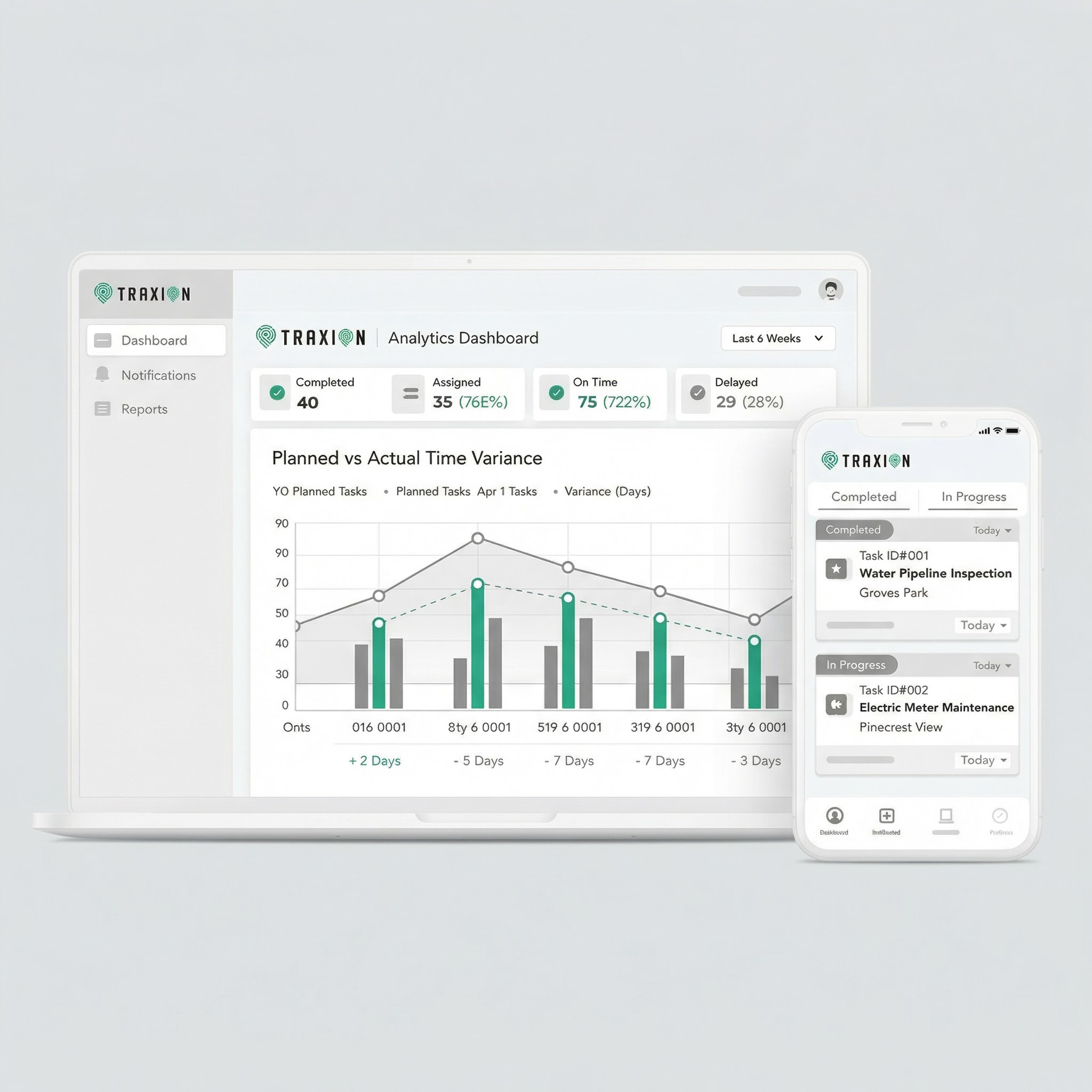
Unified platform for real-time visual insights on tasks, field teams, inventory, and costs—all managed through a powerful central dashboard.
Every task, asset, and team member is geo-tagged and tracked in real-time on the map.
Geo-stamped and time-stamped evidence with photo/video verification ensuring accountability.
Mobile-first data capture flows instantly to enterprise dashboard with zero lag.
Purpose-built modules for construction phase and operations & maintenance, seamlessly integrated into one platform.
A Swiss Army knife-style toolkit to help all stakeholders manage the complex knot of tasks, people, and inventory through a powerful unified dashboard.
3D Spatial Models + Time Dimension + Cost Tracking + Energy Analysis + Facility Management for complete project visualization and planning
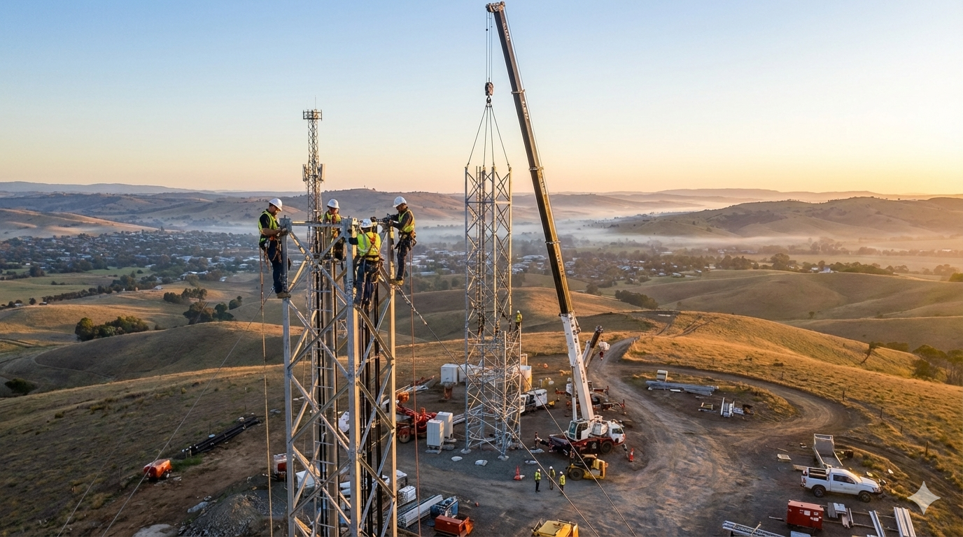
Visual insights into construction progress across thousands of kilometers of network infrastructure
Real-time variance tracking between planned and executed work with deviation alerts
Track materials, equipment, and workforce across all sites with IoT integration
BUILD Module Dashboard
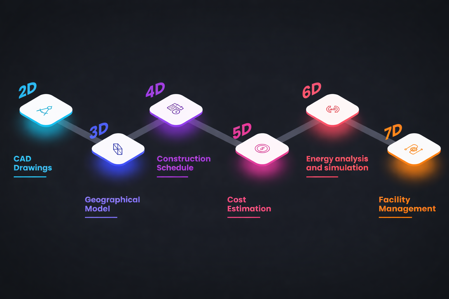
Traxion transforms infrastructure into intelligent digital twins. With 7D BIM, we integrate asset lifecycle management, predictive maintenance, sustainability analytics, and operational intelligence into one unified platform.
Real-time infrastructure models connected with live operational and asset data.
Automated maintenance scheduling, predictive servicing, and performance monitoring.
Track energy usage, asset health, lifecycle costs, and long-term sustainability metrics.
Deployed across critical infrastructure sectors managing complex, geographically distributed projects.
Fiber optic rollouts, tower construction, last-mile connectivity, and network densification projects.
Transmission lines, substations, smart grid deployments, and renewable energy infrastructure projects.
Highway construction, bridge projects, toll infrastructure, and maintenance management systems.
Pipeline construction, refinery expansions, terminal infrastructure, and maintenance operations.
Pipeline networks, treatment plants, canal systems, and smart water management infrastructure.
Urban infrastructure, street lighting, waste management, and integrated city services.
Purpose-built tools for every stage of infrastructure lifecycle. Click any feature to learn more.
Comprehensive planning tools for route optimization, network design, and clustering. Create viable project plans with geospatial intelligence and cost estimation before breaking ground.
Geo-stamped, time-stamped verification of completed tasks. Photo/video evidence with GPS coordinates ensures accountability and eliminates disputes over work completed.
Advanced mapping and visualization of project data. Heat maps, progress tracking, network analysis, and spatial relationships displayed on interactive maps.
Real-time comparison between planned and executed work. Track variances in location, timeline, and cost against original design with visual overlays.
Dynamic Gantt charts and milestone management. Track dependencies, critical path, and schedule impacts with automated alerts for delays and bottlenecks.
Track materials, equipment, and consumables across multiple sites. Real-time stock levels, automatic reorder points, and consumption analytics.
Centralized vendor portal for contractors and suppliers. Track performance, deliverables, payments, and compliance in one unified system.
End-to-end financial management from budgeting to invoicing. Track costs against budgets, automate billing, and generate financial reports with drill-down capabilities.
Ask questions about your project in plain English. "Show me delayed tasks in Zone A" or "What's the average completion rate this month?" - instant answers from your data.
Closed-loop feedback system integrating sensor data, SCADA systems, and field devices. Real-time monitoring of network health, environmental conditions, and equipment status.
Seamless bi-directional sync with SAP, Oracle, Microsoft Dynamics, and custom ERPs. Keep your existing systems while gaining TraXion's capabilities.
Optimize field team deployment, track maintenance schedules, manage incidents with FMS (Field Management System), and ensure rapid response times.
Mobile-first data capture flows instantly to enterprise dashboard. Field teams see only assigned tasks, management sees complete project status. No synchronization delays.
Network trace analysis, load flow studies, capacity planning, and engineering calculations built into the platform. No need for external tools.
Manage contracts, track deliverables, ensure regulatory compliance, and maintain audit trails. Automated alerts for contract milestones and renewals.
Visual representation of construction progress across geographic areas. Instantly identify lagging zones, resource bottlenecks, and high-performing teams.
Automated notifications based on asset location, status changes, or maintenance schedules. Proactive alerts prevent issues before they impact operations.
AI-powered route selection, network clustering, and infrastructure placement optimization considering terrain, existing utilities, and regulatory constraints.
Multi-level approval processes for designs, changes, and expenditures. Digital signatures, audit trails, and configurable routing based on project hierarchy.
Machine learning models predict project delays, cost overruns, and maintenance needs. Data-driven insights help you stay ahead of problems.
Purpose-built for infrastructure, battle-tested at scale, and designed for real-world complexity.
Your complete workflow managed on one unified platform. No switching or import/export between multiple tools, no data silos, no integration nightmares. TraXion is your single source of truth.
Zero lag between field and office. Mobile-first architecture ensures instant data flow from field teams to enterprise dashboards—no synchronization delays or batch processing.
Extensive customization without coding. Configure tasks, workflows, roles, permissions, and reporting yourself. Templates available for common scenarios, flexibility for unique needs.
Managing 1,00,000+ line kilometers, 100+ active work sites, and 1,000+ daily users. Deployed with major infrastructure leaders like Tata Power, BBNL, and BharatNet.
TraXion is built by a team with a combined experience of over three decades in location & GIS-based solutions for governments and large infrastructure execution companies in India and overseas, across various domains.
The concept for the TraXion platform was born out of a genuine lack of an end-to-end project monitoring solution and was subsequently conceptualized and developed in close consultation with industry experts and end users; the feature list is tailor-made for addressing the problems arising in large scale infrastructure project management.
Insights on infrastructure project management, GIS technology, and digital transformation.
Join India's infrastructure leaders who trust TraXion to manage their most critical projects. Schedule a personalized demo today.